|
|
HISTORY OF TYBEE |
|

|
A History of Tybee
This history of Tybee will begin at 10,000 to 8,000 years before today. Tybee was not an island. It was a hill about 100 feet above mean sea level and 30 miles from the surf. At that time, Grey�s Reef was on the water�s edge, mammoths and other extinct animals roamed the southeast, and the world was in the grips of the last ice age. It is likely that some early Indians traveled, lived and hunted in the area of Grey�s Reef and along the coastal plain between what is now the Georgia Barrier Islands and the ocean. Currently, Grey�s Reef is about 100 feet below the surface and about 30 miles from shore. Gradually, the glaciers, which produced the low sea level melted and over the intervening time the sea level rose to the present level. For more information, go to the Grey�s Reef net site:
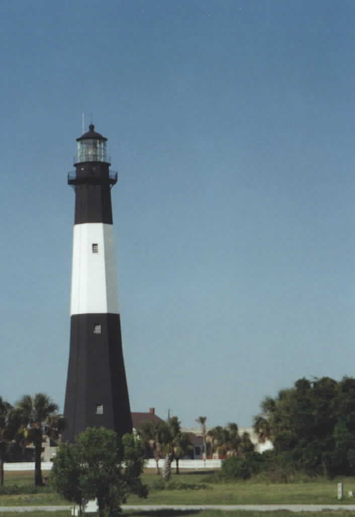
The next important era for Tybee is the exploration years when Europeans prowled the Georgia coast seeking valuables, claiming territory, and trying to kill each other. All of the major European sea-going powers, England, Spain, and France, entered into the fray. Eventually, France pulled out and England settled Savannah. Oglethorpe initially landed on Tybee before he sailed the ship, Anne, up river to the bluffs where he founded Savannah. In addition to establishing a colony for the purposes of making money for the crown, one of Oglethorpe�s main goals was to block the progress of the Spaniards up the coast. To do this, he built a series of small forts on barrier islands south of Tybee. For more information, see: This historical site, created by Katherine D. Ferreira, has additional history about Tybee as well as many good pictures of the last half of the 1800�s and the pre-World War I period. It is part of the Savannah Images Project, which is sponsored by the Armstrong Atlantic State University in Savannah. The SIP site is a good place to start any online study of Savannah and the surrounding area. Oglethorpe ordered the construction of the first Tybee lighthouse in 1734. The Tybee Light has taken several forms but has been a safety beacon almost continuously since the first. This was the first of many important government sites established on Tybee. It is maintained by a non-profit organization and the Coast Guiard keeps the light burning. There is technical and historical information about the Tybee Light at: An interesting picture of the Hale-Bopp Comet and the current lighthouse can be found at the following site, as well as a multitude of information about Tybee today. For years, the population was small and eked out a subsistence level livelihood on the land and from the waters. The second technological intrusion was the establishment of Union artillery batteries on the northwest coast of Tybee in 1862, during the Civil War. The five batteries lay siege to Fort Pulaski on Cockspur Island, about one mile away. This was the first use of rifled cannons against a fort. The fort was armed with ball firing cannons, which could not reach the Federal position. The siege only lasted 30 hours and the fort surrendered with the southeastern wall destroyed. The damage can still be seen. The Civilian Conservation Corps rebuilt the fort during the 1930�s and the newer part can be seen as distinctly lighter colored bricks. The National Parks Service site on Fort Pulaski is located at: This site includes a picture, which clearly shows the old and rebuilt portions of the wall. For a description of an archeological examination of a Federal battery on Tybee see: After the Civil War, Tybee suffered under Reconstruction like the rest of the South. Finally, in the 1880�s developers saw the advantages to changing Tybee�s wilderness in to a small town. They laid out a plan which is the same as today. The establishment of the railroad between Savannah and Tybee was the turning point for the development of the island. The railroad was completed in 1887 and served the vacationers going to Tybee for over 30 years. The railroad cut the travel time in half, to about 90 minutes. Before the railroad, travel to Tybee was by steamer, arriving at the north end. Vacationers were transported to the south end by horse drawn carts. When the highway, which became U.S. 80, was completed, railroad use dwindled until it was closed on July 31, 1933. The first Tybee Hotel was built in 1891 and then burned down in 1908. The second Tybee hotel was completed in 1911 and was in use until it was torn down for other construction in 1958. The location was between 13th and 14th streets. John Mack Adams's book, Tybee Island, has a good collection of pictures of Tybee between the late 1800's and about 1930. These included pistures of Fort Pulaski, Fort Screven, Tybee light, the Tybrisa, the old and new Tybee Hotel Tybees, and many other interesting views. World War I stopped development on Tybee except for Fort Screven, which blossomed into a first rate military stronghold. The fort was a training station for thousands of U.S.troops before they went to fight the War to end all Wars. There has been a fort at the north end of Tybee at various times since the period of Oglethorpe. The beginnings of Fort Screven were started during the Spanish-American War and after several name changes it was designated Fort Screven in 1899. There are numerous pictures of the life at the fort. Again the Savannah Images Project is one of the best sources for pictures. The fort and most of its fine old houses were sold to private owners and additional houses have been built. Some of the owners of the homes between the fort and the sea wall might be surprised to learn that it was the location of the WWI firing range and during the 1950�s both spent cartridges and live ammunition was found between the cockspurs. During World War II, Tybee was a place, which had a visible military presence. The houses were blacked out at night to prevent them being seen by German U-boats. In addition, there were armed Coast Guard horseback patrols at night on the beach, which was closed from dusk to dawn. There were fines and detainment for a violation of the beach curfew and for showing visible lights. Traffic on the Tybee Road was restricted to emergency traffic. Until the 1950�s, there were the remnants of a watchtower at the mouth of Back River. Between the World Wars, there was a growth in building in the mid beach area. Most of the older houses between Butler Avenue and the beach were constructed then. During World War II, another stop in development occurred because of the lack of materials. Again, after the war the value of beach homes became apparent and construction resumed. Many of these houses were rented for some portion of the summer. During this time and later, the number of year-round residents increased. Before this Tybee was seen as a summer place. Later, especially after highway improvements, the number of permanent residents increased markedly. Author's Note: I lived every summer at Tybee from 1945 until 1960, and my parents were there until 1971. It has a special place in my heart. I am convinced there is no better family resort. For more information about Tybee today, enter "Tybee" into any Internet search engine and follow the links. Also, there are numerous books. Two of the most recent include James Mack Adams, Tybee Island (Arcadia Publishing, Charleston, 2000) which I have already mentioned. The second is Running with the Dolphins by Michael Elliott (Smyth and Helwys, Macon, 1995). The latter contains stories which give the flavor and colorfulness of Tybee today. If you have any corrections for this article or any information which you feel should be added, I can be reached at: Milton Coward
The above history was written to further our understanding and knowledge of the area. Many thanks to Milton who worked so hard to get this information for us.
|